





















+977-9768558250
Search Tours or Places
Blog / India

Ladakh Travel Guide: Leh, Pangong Lake and Best Season

34 min read 19 Nov 2026
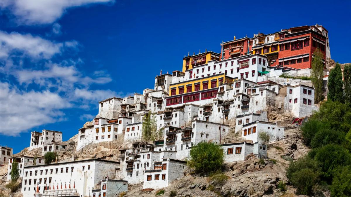
Thiksey Monastery rising in white tiers up a hillside under a deep blue Ladakh sky

Short answer: Ladakh is India's high-altitude desert in the far north, a Union Territory since 31 October 2019, with its main town Leh at about 3,500 m. Go between June and September, when the roads are open and the sky is dry. Then rest for at least 48 hours in Leh before you head higher. Indian nationals no longer need an Inner Line Permit. Most foreign nationals need a Protected Area Permit for Nubra, Pangong Lake, Tso Moriri and other border areas. Citizens of Bhutan are exempt from that permit, while Nepali citizens should confirm their own rule with the Leh district administration before travelling.

That is the trip in one paragraph. The rest of this guide covers what the short answer skips: Khardung La's real height compared with the number on its signboard, why flying into Leh is harder on the body than walking to Namche Bazaar, which permit pages are official and which fee slips are fake, and how to time Leh Ladakh around Nepal's monsoon and festivals. We checked every rule and figure against the Leh district administration, the official permit portal, the Union Territory of Ladakh's press releases and the CDC on 18 November 2026. Where sources disagree, we say so.

Why visit Ladakh?

Ladakh is worth the effort because nowhere else in India packs this much high-desert scenery, living Buddhist culture and road adventure into one region. In a single week you can watch dawn prayers at a 15th-century monastery, cross a pass at over 5,300 m, ride a Bactrian camel on sand dunes and stand beside a lake that changes from blue to green as clouds pass.

Ladakh became a separate Union Territory of India on 31 October 2019, and the administration in Leh now sets its own visitor rules. The region sits north of the main Himalayan range, in its rain shadow. That is why the landscape is bare rock, scree and sand, with green villages only where glacier streams reach the valley floor. The Indus River runs through the middle of it, past Leh, Thiksey and Hemis. To the north lie the Ladakh range and the Nubra and Shyok valleys. To the east is the Changthang plateau with Pangong Tso and Tso Moriri. The Leh district tourism pages describe the region's elevation as ranging from about 8,370 ft to 25,400 ft above sea level.

Ladakh formally opened to tourism in 1974, when only 527 tourists arrived, according to the Leh district tourism page. Tourism now accounts for more than 60 percent of the region's revenue. The same page counts about 290 hotels, 691 guest houses, 1,055 homestays and 105 camps in Leh district. Homestays are a real option here, not a novelty, and they put money straight into village households.

If you are still deciding where Ladakh fits in a wider India trip, our complete India travel guide covers the country as a whole, and the regional overview of the best places to visit in India shows how Ladakh compares with Rajasthan, Kerala and the other Himalayan states.

Who Ladakh suits best:

  • Bikers and road-trippers: the Manali to Leh highway and the high passes are bucket-list rides in their own right.
  • Photographers: clear, dry air, deep blue skies, monasteries on ridges and, at Hanle, India's first dark sky reserve.
  • Trekkers, including those who have walked in Nepal: the Markha Valley, Sham Valley and winter Chadar routes start from Leh.
  • Culture travellers: monastery festivals with masked cham dances, royal palaces and a Buddhist way of life that feels familiar to many Nepali visitors from Mustang, Manang or Dolpa.
  • Wildlife watchers: Hemis National Park is known for snow leopards, and the lakes draw bar-headed geese and black-necked cranes in summer.

When is the best time to visit Leh Ladakh?

The best time to visit Leh Ladakh is June to September. In those months both road routes are normally open, Pangong and Nubra are reachable, and the region stays dry while the monsoon soaks the rest of India and Nepal. May and early October are good shoulder months if you accept colder nights and the chance of road closures. From November to March, Leh is reachable only by air, and the trip becomes a specialist winter journey.

According to the Leh district "How to Reach" page, summer temperatures rarely exceed 30 degrees Celsius, while winter nights can drop to minus 30 degrees Celsius. The same page gives the Manali to Leh road's usual season as May or June to September or October. In 2026 the Border Roads Organisation finished clearing snow on the highway on 12 May, after 42 days of work, and light vehicles were allowed through via Baralacha La on 15 May, as The Tribune reported on 16 May 2026. Opening dates depend on snowfall and change every year.

The table below shows what each part of the year looks like for a visitor. Road dates are typical ranges, not promises. Check the current status before you book.

MonthsSeasonAccessWhat it is good forWatch out for
January to FebruaryDeep winterFlights to Leh only; Manali road closedChadar trek on the frozen Zanskar, snow leopard trips, monastery winter festivals, frozen lakesNights far below freezing; Chadar start depends on stable ice
March to AprilLate winterFlights; roads still largely closedQuiet Leh, apricot blossom in April in the lower Indus valleyCold, limited services outside Leh
MayOpening of the seasonManali road usually reopens in mid to late May (12 to 15 May in 2026)Fewer crowds, snow on the high passesLate snowfall can close passes again
June to SeptemberPeak seasonFlights plus the road routesPangong, Nubra, Tso Moriri, Hemis Tsechu, biking, trekkingBusiest months; book stays early
OctoberShoulderFlights; Manali road usually closes in late September or OctoberClear skies, autumn colours in the villages, Diskit Gustor festivalFreezing nights; seasonal camps at the lakes wind down
November to DecemberEarly winterFlightsThiksey Gustor and other winter festivals, empty monasteriesVery cold, road travel limited

For the national picture, our guide to the best time to visit India month by month explains why Ladakh's summer window runs opposite to the October to March season that suits the plains, Rajasthan and Goa.

What about Ladakh in winter and the Chadar trek?

Winter Ladakh suits prepared visitors. The Chadar trek follows the frozen Zanskar River and depends on stable ice. In January 2026 the Leh administration postponed the trek's scheduled 10 January start because stretches of the river had not frozen enough, as a news report on 12 January 2026 described, while officials surveyed sites for campsites, medical facilities and rescue points. Treat any Chadar date as provisional until the Leh administration confirms the ice is safe, and expect temperatures far below freezing.

Checked: 18 Nov 2026, Leh district tourism pages, The Tribune (Manali road reopening, May 2026), news report of 12 Jan 2026 (Chadar delay).
Explore India tour packages
View all →

How should you acclimatise on arrival in Leh?

Rest is the plan for your first two days in Leh. The Leh district permit portal's health advisory says that all visitors arriving in Leh must spend at least 48 hours acclimatising before travelling on to higher areas, with no strenuous activity during the first two days. That means no Khardung La, no Pangong and no monastery stair-climbing on day one, however well you feel when you step off the plane.

Why so strict? Flying from Delhi lifts you from near sea level to an airport at about 3,256 m in roughly an hour. The CDC Yellow Book chapter on high-altitude travel (last reviewed 23 April 2025) advises against going directly from low altitude to a sleeping altitude of 2,750 m (9,000 ft) or more in one day. Above 3,000 m, it recommends raising your sleeping altitude by no more than 500 m per day, with an extra acclimatisation day for every additional 1,000 m. A flight to Leh breaks the first rule by design, so the rest days are your safety margin.

Acclimatisation checklist for Leh

  • Days 1 and 2: rest, short flat walks in Leh at most, light meals. The district advisory recommends complete rest for 24 to 36 hours and at least 48 hours before going higher.
  • Drink enough: the advisory suggests 2 to 3 litres of water a day.
  • No alcohol, smoking or sleeping pills: both the advisory and the CDC say to avoid alcohol for the first 48 hours, and the CDC warns against alcohol and other sedatives as sleep aids at altitude.
  • Medicine is a doctor's decision: the district advisory mentions acetazolamide (Diamox) starting before arrival. It is a prescription medicine with side effects and conditions where it should not be used, so ask your doctor before the trip rather than buying it over the counter.
  • Climb in steps: after Leh, go to Nubra (lower, around 3,100 m at Diskit) before Pangong or Tso Moriri, and avoid sleeping at the lakes on your first trip out of Leh.
  • Never go higher with symptoms: the CDC says never to ascend to sleep at a higher altitude while you have symptoms of altitude illness, however minor they seem.

Signs of altitude sickness to watch for

Acute mountain sickness (AMS) usually starts 2 to 12 hours after arrival, according to the CDC, and headache is its main symptom. The district advisory lists the danger signs as headache, nausea, coughing, lassitude, lack of concentration, disturbed sleep, loss of appetite, irregular breathing and breathlessness.

ConditionTypical signsWhat to do
Acute mountain sickness (AMS)Headache plus nausea, dizziness, tiredness or poor appetiteRest at the same altitude, do not go higher, see a doctor if it does not improve
High-altitude pulmonary edema (HAPE)Cough, chest congestion, breathlessness on light effort, later breathlessness at restMedical emergency: get to a doctor and descend
High-altitude cerebral edema (HACE)Confusion, drowsiness, loss of balance or coordinationMedical emergency: descend immediately and get medical help

The CDC notes that AMS improves quickly with a descent of 300 m or more, and that descent becomes mandatory if symptoms get worse despite treatment. In Leh, the main government hospital is SNM Hospital. The district's health advisory page lists the current emergency contacts, so save it on your phone before you go out of town.

Road travellers are not exempt. The Leh district "How to Reach" page says that people who arrive by road acclimatise with the gradual climb. The permit portal's health advisory says that road travel "does not help at all" and still asks for 48 hours of rest in Leh. The honest reading is that the road gives you a slower start, but the Manali route crosses passes above 16,000 ft, higher than Leh itself, and overnight stops on the way can be high and cold. Take the rest days either way.

Checked: 18 Nov 2026, Leh district permit portal health advisory (www.lahdclehpermit.in/healthadvisory), Leh district How to Reach page, CDC Yellow Book.

How high are Leh, Khardung La and the lakes?

Leh sits at about 3,500 m, and most day trips take you well above 4,000 m. Published altitudes for the same place often differ by 100 to 250 m. The table gives the figure from each source we checked, so you can see where the gaps come from.

PlaceAltitudeSource and note
Leh townAbout 3,500 m (11,500 ft)Commonly given figure; different parts of town are listed between about 3,500 and 3,524 m
Leh airport (Kushok Bakula Rimpochee, IXL)About 3,256 m (10,682 ft)Published airport elevation
Diskit, Nubra ValleyAbout 3,144 mLower than Leh, a good first overnight out of town
Lamayuru Monastery3,510 mLeh district tourism page
Pangong TsoAbout 4,225 to 4,350 mLeh district page: 14,270 ft (about 4,350 m); survey-based references: about 4,225 m
HanleAbout 4,500 mLeh district tourism page
Tso MoririAbout 4,500 to 4,600 mRamsar site listing: about 4,595 m; the Leh district page rounds it down to "about 4000 metres"
Khardung La5,359 m (17,582 ft) measured; 5,602 m (18,379 ft) on signsSee the next section

Is Khardung La really the highest motorable road?

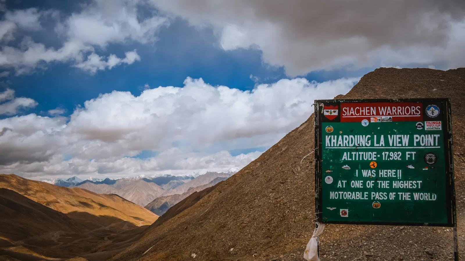
Khardung La View Point signboard reading 17,982 ft above brown mountain slopes in Ladakh

No. Khardung La is high, but it is not the world's highest motorable road, and its famous number is too high. The Leh district's own Khardung La page gives 18,379 ft (5,602 m), the same figure painted on the summit signs. GPS surveys and NASA's SRTM elevation data put the pass at about 5,359 m (17,582 ft), as the Khardung La reference entry explains with its sources. The sign is about 240 m too high. Even the boards disagree: the "Khardung La View Point" board in the photo above reads 17,982 ft.

The same district page now calls Khardung La the second-highest motorable pass in the world, after Umling La, also in Ladakh. The Border Roads Organisation's road at Umling La reaches 19,024 ft (about 5,799 m). It was completed in 2021 and recognised by Guinness World Records. In October 2025 the BRO reported an even higher alignment at Mig La, about 19,400 ft, on the Likaru to Mig La to Fukche road in eastern Ladakh, as reported by Outlook Traveller on 9 October 2025. Access to those border roads for visitors depends on permits that change, so check before you plan around them.

None of this makes Khardung La less dramatic. It is about 40 km from Leh, it is the gateway to the Nubra and Shyok valleys, and 5,359 m is roughly the height of Everest Base Camp. Keep your stop at the top short, move slowly, and drop down the far side if anyone in your car feels unwell.

How does Ladakh's altitude compare with trekking in Nepal?

Leh is about as high as Namche Bazaar, and Khardung La is about as high as Everest Base Camp. The difference is how you get there. On the Everest trail most people take a week or more to climb from Lukla to base camp, with rest days built in. In Ladakh you can fly to over 3,200 m in an hour and be driven over a 5,300 m pass a day or two later. For many Nepali trekkers this is the trap: "I did Everest Base Camp, so Ladakh will be easy." Your body does not remember last year's trek.

LadakhApprox. altitudeNepal comparisonApprox. altitude
Leh airport3,256 mLukla airport2,860 m
Leh town3,500 mNamche Bazaar3,440 m
Pangong Tso4,225 to 4,350 mDingbocheAbout 4,410 m
Khardung La (measured)5,359 mEverest Base CampAbout 5,364 m
Umling La roadAbout 5,799 mHigher than Thorong La on the Annapurna CircuitAbout 5,416 m

Nepal figures are commonly published, rounded trail altitudes.

Do you need permits for Pangong, Nubra and other areas?

It depends on your nationality. Indian nationals do not need an Inner Line Permit for Ladakh, but they still pay the environment and related fees through the official portal. Most foreign nationals need a Protected Area Permit for Nubra, Khardung La, Pangong, Tso Moriri and similar areas, usually arranged through a registered Leh travel agency. Citizens of a short list of countries need clearance from India's Ministry of Home Affairs in New Delhi. The permit rules exempt citizens of Bhutan. We could not find an official statement that covers Nepali citizens, so confirm with the Leh district administration before you go.

The Ladakh administration removed the Inner Line Permit requirement for Indian nationals by an order dated 6 August 2021, and stays for foreign tourists in border circuits were extended from 7 to 15 days at the same time, as reported by GKToday on 7 August 2021. On 7 September 2026, a UT Ladakh press release repeated that "domestic tourists are not required to obtain an Inner Line Permit". It also said permits "remain mandatory for notified areas". The Leh District Tourist Management System is the official portal for permits and fees. A notice on its home page confirms that the existing fee structure continues for visitors, covering the environmental fee (green fee), a Red Cross fund and a wildlife fee. The portal also hosts the Ministry of Home Affairs questions and answers on Protected Area Permits, which state that every foreigner, except a citizen of Bhutan, needs a special permit to enter a protected area.

This table sums up what official pages said on 18 November 2026. It is a starting point, not legal advice. Rules near the border can change at short notice.

TravellerInner Line or Protected Area PermitFees through the portalWhere to confirm
Indian nationalsNo Inner Line Permit since August 2021; some notified border circuits still need registrationYes, environment and related fees applyLeh permit portal, domestic section
Nepali citizensNo official statement found. The permit rules name an exception only for Bhutan, so do not assume you are exemptCheck when you confirm the permit ruleOffice of the Deputy Commissioner, Leh, or the Leh permit portal helplines
Bhutanese citizensExempt from the Protected Area Permit under the Ministry of Home Affairs rules hosted on the portalCheck whether the environment and related fees applyOffice of the Deputy Commissioner, Leh
Most other foreign nationals, including NRNs on foreign passportsProtected Area Permit needed for Nubra, Khardung La, Pangong, Tso Moriri and similar areas; Leh town needs noneYes, a fee appliesLeh permit portal, overseas section, or a registered Leh agency
Citizens of Pakistan, Afghanistan, China, Bangladesh, Myanmar, Sri Lanka, Taiwan and Hong Kong, and foreign nationals of Pakistani originProtected Area Permit from the Ministry of Home Affairs, New DelhiAsk when applyingMinistry of Home Affairs, Government of India
Diplomatic, UN, official and journalist passport or visa holdersProtected Area Permit from the Ministry of External Affairs, New DelhiAsk when applyingMinistry of External Affairs, Government of India

Practical points for every visitor:

  • Use the official portal only. Type the full address with "www" (www.lahdclehpermit.in). On 18 November 2026 the version without "www" showed an expired security certificate.
  • Beware of fake fee slips. On 21 September 2023 the Additional Deputy Commissioner of Leh warned that private agencies and individuals had issued fake environmental fee slips. Pay through the portal or a registered agency and keep the printout.
  • Carry copies. Designated checkpoints on the roads out of Leh check permits and fee slips. Carry several printed copies and your original ID.
  • Hanle and the far east are a special case. Hanle, Umling La and areas close to the border appear as separately listed circuits on the portal, and access for foreign nationals there is more restricted. Confirm with a registered Leh agency before you build a trip around them.

What is the environment fee?

The environmental fee, or green fee, is a charge that the Ladakh Autonomous Hill Development Council (LAHDC) Leh has collected since a 2012 order. The money goes towards protecting the region's fragile environment. Collection was confirmed again in a council notice of October 2021. A fee applies to visitors heading out of Leh, together with the Red Cross and wildlife components. Amounts are set by the administration and can change, so check the current figure on the official portal rather than trusting a number from a blog. The portal also asks visitors to bring their rubbish back from the valleys and drop it at the Tsangda waste segregation project on the way back to Leh.

Do you need an Indian visa for Ladakh?

Nepali citizens do not need an Indian visa, and our guide on whether Nepalis need a passport for India explains which identity document to carry. Everyone else, including NRNs on foreign passports, should see our India visa page. A visa gets you into India. It does not replace the Protected Area Permit for Ladakh's restricted areas.

Checked: 18 Nov 2026, Leh District Tourist Management System (home page notices, circuits list and restricted-nationality notice), UT Ladakh press release of 7 Sep 2026, LAHDC notices of October 2021 and 21 Sep 2023.

What is Pangong Lake like and when is it frozen?

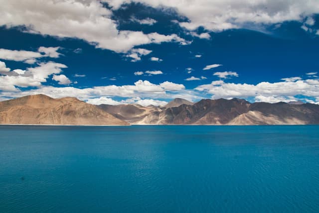
Turquoise water of Pangong Lake curving beneath bare brown mountains in eastern Ladakh

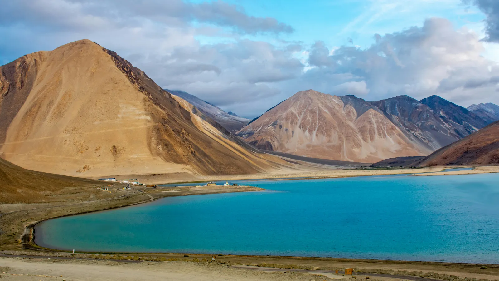
Pangong Lake (Pangong Tso) is a long, narrow, brackish lake at roughly 4,225 to 4,350 m in eastern Ladakh. It is famous for water that shifts between deep blue, turquoise and grey-green with the light. It freezes completely in winter, so a January visit shows a white sheet of ice rather than the blue lake in the photos. Most visitors see it between June and September.

The Leh district Pangong page describes the lake as about 134 km long and up to about 5 km wide. Geographically, only about a third of it lies in Ladakh. The rest extends east into Tibet. Visitors see the western end, reached via Tangtse and Lukung. The district page notes that the lake is a summer breeding ground for bar-headed geese, Brahminy ducks and black-necked cranes.

What to expect on a Pangong trip:

  • The road: the permit circuit runs Leh, Kharu, Chang La, Durbuk, Tangtse, Lukung. Chang La is another very high pass, so the drive is a long, tiring day.
  • Stays: camps and simple guest houses near the lakeshore, mostly seasonal. Nights are cold even in July. Do not expect luxury hotels.
  • Altitude: sleeping at Pangong is higher than sleeping in Leh. Go only after your Leh rest days, ideally after a night in Nubra.

When it freezes: the district page says the lake "freezes completely" in winter despite its saline water. The deepest freeze usually falls in the coldest months, January and February. Ice thickness varies from year to year and from shore to centre, so never walk out onto the ice unless local authorities or guides have cleared it. Winter road access to the lake depends on snow on Chang La.

Pangong or Nubra: which should you choose?

If you only have time for one overnight trip from Leh, choose Nubra on a first visit and Pangong once you are well acclimatised. Many travellers do both. The comparison below uses the district figures and permit circuits quoted above.

FactorNubra ValleyPangong Lake
Sleeping altitudeAround 3,100 to 3,200 m, lower than LehAround 4,225 to 4,350 m, much higher than Leh
Pass on the wayKhardung LaChang La
Distance from LehAbout 120 km north (district figure)A long day's drive east via Chang La
HighlightsDiskit Monastery and Maitreya statue, Hunder dunes, Bactrian camels, Turtuk village, Panamik hot springColour-changing lake, birdlife, big open landscape
StaysGuest houses, homestays and camps in Diskit and HunderSeasonal camps and simple guest houses
Best forFirst trip out of Leh, families, culturePhotographers, second trip once acclimatised
Permit for most foreign nationalsYesYes

What else should you see: Nubra, monasteries and Leh Palace?

Beyond Pangong, the essential Ladakh sights are the Nubra Valley, the monasteries of the Indus valley, especially Thiksey, Hemis, Lamayuru and Alchi, and Leh's old town with its palace and Shanti Stupa. Tso Moriri and Hanle reward travellers with more time and good acclimatisation. Here is what each one offers and how it fits around Leh.

Nubra Valley and the Hunder dunes

Double humped Bactrian camels resting on sandy ground in Nubra Valley, Ladakh

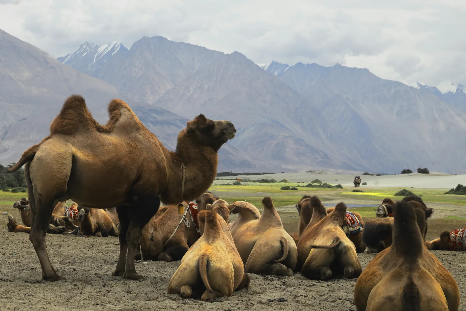
Nubra lies about 120 km north of Leh across Khardung La. Its old name, Ldumra, means "valley of flowers", according to the Leh district Nubra page. The valley is greener and lower than Leh, with apricot orchards, the sand dunes of Hunder and herds of double-humped Bactrian camels. Diskit is the main town. Further west along the Shyok River, the village of Turtuk shows a different culture again, with buckwheat fields and a maze of stone lanes. Panamik is known for its hot spring. The district notes that the Siachen Glacier base camp has been opened to domestic tourists only.

Diskit Monastery

Diskit Monastery buildings clinging to a rocky slope above the Nubra Valley

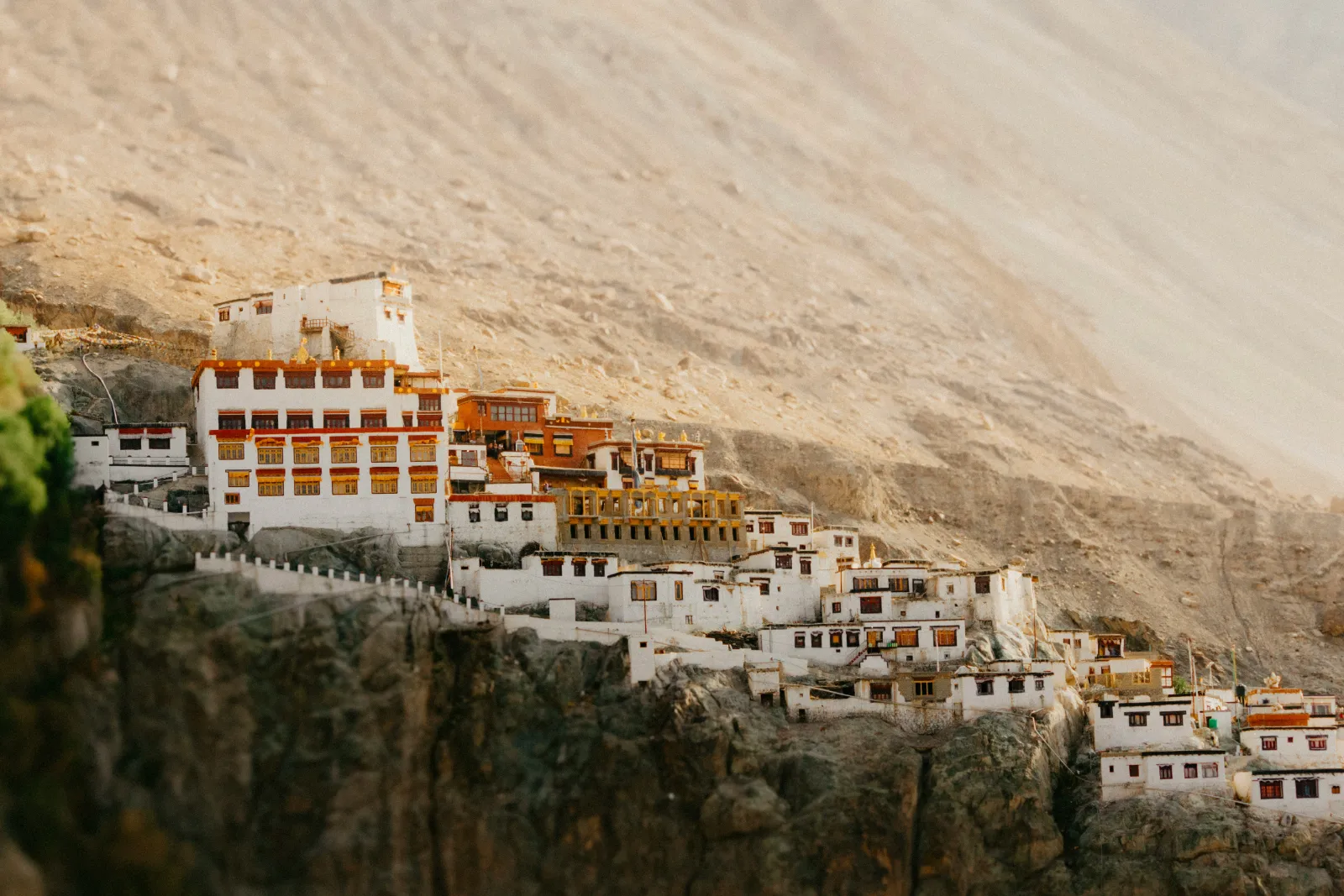
Diskit Monastery is the main monastery of Nubra. It dates from the 14th century, belongs to the Gelug school and is linked to Thiksey. Below it, a giant seated Maitreya Buddha of about 32 m looks down the valley. It was consecrated in 2010. Go in the morning, when the light falls on the whitewashed buildings, and walk up slowly, because even at around 3,100 m the steps are steep.

Thiksey, Hemis, Lamayuru and Alchi monasteries

The Indus valley monasteries are the cultural heart of Ladakh, and most can be visited as day trips from Leh.

  • Thiksey Monastery is about 19 km from Leh. Founded in 1433, it is the largest monastery in central Ladakh, its white buildings rising in tiers up the hill. It has a 15 m (48 ft) Maitreya statue from the 1980s, and visitors can attend the morning prayers, according to the district Thiksey page. Arrive early and sit quietly at the back.
  • Hemis Monastery is about 45 km from Leh and belongs to the Drukpa lineage. It hosts the Hemis Tsechu festival honouring Guru Padmasambhava, with masked cham dances in the courtyard. Hemis National Park, which the district describes as the largest national park in South Asia, is nearby and known for snow leopards.
  • Lamayuru is about 115 km west of Leh. Its 11th-century monastery stands at 3,510 m above eroded "moonland" formations, and the Yuru Kabgyat festival is held there in summer.
  • Alchi is about 65 km west of Leh on the south bank of the Indus, at around 3,100 m. Its temples date from roughly the 12th to 13th centuries and hold some of the oldest surviving wall paintings in Ladakh.

Monastery etiquette: dress modestly, walk clockwise around stupas and prayer wheels, ask before photographing monks, and keep voices low during prayers. Nepali visitors from Buddhist areas such as Mustang, Manang, Solukhumbu or Boudha will recognise much of this.

Leh Palace and the old town

Stone walls and wooden balconies of Leh Palace above a paved path in Leh

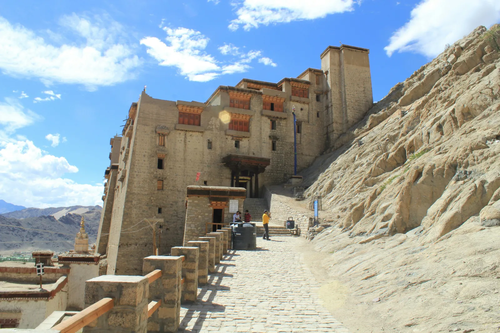
Leh Palace was built for King Sengge Namgyal in the first half of the 17th century and rises nine storeys over the old town. It is a good second-day visit if you take the steps slowly. The old town lanes below make a gentle acclimatisation walk.

Shanti Stupa

White domed Shanti Stupa in Leh with painted panels against a blue sky and dry hills

Shanti Stupa is the white peace pagoda on a hill above Leh. It was built in 1991 by the Japanese Buddhist monk Gyomyo Nakamura to mark 2,500 years of Buddhism, and the district Shanti Stupa page notes that relics of the Buddha enshrined by the 14th Dalai Lama lie at its base. Come at sunset for the view over Leh. A road also reaches the stupa, so you do not need to climb the long staircase in your first days.

Tso Moriri, Hanle and the Changthang plateau

Tso Moriri is a quieter, higher alternative to Pangong. It lies about 240 km from Leh via Upshi, Chumathang and Sumdo, which the district says takes about 6 to 7 hours, and it is part of the Tsomoriri Wetland Conservation Reserve, a Ramsar site since 19 August 2002. Hanle, about 260 km from Leh at around 4,500 m, is home to the Indian Astronomical Observatory and the Hanle Dark Sky Reserve. The Indian Institute of Astrophysics says the reserve was declared in December 2022 and covers a radius of about 22 km around Hanle. Both places are very high, very cold at night and have basic lodges and homestays. They suit travellers who have already done Nubra and Pangong without trouble.

Which Ladakh festivals happen when?

Ladakh's monastery festivals follow the Buddhist lunar calendar, so their Gregorian dates move each year. The Leh district festival calendar lists the months below. Dates for 2027 had not been published when we checked on 18 November 2026.

FestivalUsual monthWhere
DosmocheyFebruaryLeh, Likir, Diskit
Ladakh Winter Snow Leopard FestivalFebruaryHemis National Park, Rumbak
Apricot Blossom FestivalAprilCentral and lower Indus valley
Hemis TsechuJune (late June or the first half of July)Hemis Monastery
Yuru KabgyatJuneLamayuru
Phyang TsedupJulyPhyang Monastery
Korzok GustorJulyKorzok, Tso Moriri
Diskit GustorOctoberDiskit Monastery
Thiksey GustorNovemberThiksey Monastery

For Hemis Tsechu 2027, watch the Leh district and Hemis Monastery announcements in spring 2027. The festival falls on the 10th day of a lunar month, so its Gregorian date shifts from year to year.

Checked: 18 Nov 2026, Leh district tourist place pages and festival calendar, Ramsar Sites Information Service, Indian Institute of Astrophysics.

How do you get to Leh: by flight or by road?

From Kathmandu, the simplest way to Leh is to fly Kathmandu to Delhi (about 1.5 to 2 hours non-stop), then take a domestic flight from Delhi to Leh (about an hour). Delhi to Leh flights run all year, weather permitting. By road, the Manali to Leh highway is the classic overland route in summer and crosses some of the highest passes in the Himalaya. It is spectacular, but it takes two days and needs good health.

Leh's airport is Kushok Bakula Rimpochee Airport (IATA code IXL), at about 3,256 m. It is often described as India's highest commercial airport. Non-stop flights connect it with Delhi all year, and airline schedules also list a few other Indian cities, some only in season. Flights operate mainly in the morning, because strong afternoon winds in the mountains make later landings difficult. Weather delays and cancellations happen, especially in winter. If you are connecting from Kathmandu, avoid a same-day international to Leh connection on separate tickets. A night in Delhi gives you a buffer, and our guide to places to visit in Delhi can fill a spare evening.

The main ways to reach Leh, compared:

RouteDistance or timeSeasonGood forConsider
Fly Kathmandu to Delhi, then Delhi to LehAbout 1.5 to 2 hours, then about 1 hourAll yearMost travellers, short trips, families, older travellersFastest climb in altitude, so the 48-hour rest is essential
Fly to Leh from Mumbai, Chandigarh or JammuVaries by citySome routes seasonalDiaspora and Indian connectionsCheck current schedules with the airlines
Manali to Leh highwayAbout 427 to 473 km depending on the source (BRO and district figures), usually 2 days with a night stopRoughly May or June to September or OctoberBikers, road-trippers, fit travellersVery high passes, cold night halts, landslides and snow
Srinagar to Leh road via Zoji La and KargilAbout 434 km (district figure)The district gives May to November or December; winter closure length variesAn alternative road access routeCheck road status before travel

The Manali route has become easier since the Atal Tunnel opened on 3 October 2020. The 9.02 km tunnel runs under the Rohtang Pass at about 3,000 m and saves around four hours between Manali and the Lahaul valley, as Deccan Herald reported at the opening. Beyond the tunnel, the highway still crosses Baralacha La, at over 16,000 ft, and other passes. Those sections reopen only after the BRO clears the winter snow, so the tunnel does not make the route open all year.

Kathmandu to Manali is a long overland journey in itself. To compare trains, domestic flights and hired cars for that leg, see our guide on how to get around India. Inside Ladakh, most visitors use local taxis or a rented car or motorbike with a driver who knows the high roads. Self-drive visitors should check the current rules on outside vehicles and local permits with the Leh administration before they go.

Checked: 18 Nov 2026, Leh district How to Reach page, airport published data, Newswav and The Tribune (Manali to Leh highway, May 2026).

What should you pack and know about phone connectivity?

Pack for cold mornings, strong sun and dry air, even in July. If you rely on an Indian SIM, ask your operator before you travel whether it works in Ladakh. Mobile coverage is good in Leh and patchy or absent in parts of Nubra, Pangong, Tso Moriri and on the high passes. Download offline maps and tell someone your route before you leave town.

Packing list for a summer Ladakh trip

  • Layers: thermal base layer, fleece and a warm down or synthetic jacket. Pangong and Khardung La can be near freezing on a July morning.
  • Sun protection: UV is intense at 3,500 m and above. Bring sunglasses, a brimmed hat, high-factor sunscreen and lip balm.
  • Dry air care: moisturiser, saline nasal spray and a refillable water bottle (aim for the 2 to 3 litres a day the health advisory recommends).
  • Health kit: any prescription altitude medicine your doctor advises, your regular medicines in their original packs, and basic first aid. Check that your travel insurance covers high altitude and emergency evacuation.
  • Documents: your passport or other valid ID, an Indian visa where needed, permit printouts and several photocopies for checkpoints.
  • Power: a power bank and spare camera batteries. Batteries drain faster in the cold, and remote camps may have limited charging.
  • Cash: carry some Indian rupees for remote villages and camps, where cards and network coverage can be unreliable.

Do prepaid SIM cards work in Ladakh?

Possibly not, and we could not confirm the current rule. Many visitors report that prepaid SIMs issued in other Indian states do not work in Ladakh while postpaid connections do, but we found no current official notice from India's Department of Telecommunications that sets this out. Ask your operator before you travel.

For visitors from Nepal and abroad:

  • Nepali SIM cards: check with Nepal Telecom or Ncell whether international roaming works in Ladakh specifically, not just "in India".
  • Coverage: expect good coverage in Leh town, coverage in the main villages of Nubra and around Pangong that depends on the network, and dead zones on passes and long stretches of road.

How should Nepali travellers plan a Ladakh trip?

Nepali travellers have two real advantages in Ladakh: no Indian visa, and a cultural and mountain landscape that already feels familiar. The main risks are timing and altitude. Plan around Nepal's own calendar, not just Ladakh's.

  • Dashain and Tihar fall late for Ladakh. These festivals usually fall between late September and early November, when Ladakh is at the very end of its season, with freezing nights, seasonal lake camps winding down and the Manali road near closure. A Dashain trip works best as a fly-in Leh, Nubra and monastery trip rather than a road journey.
  • Ladakh is a monsoon escape. From June to September, while Nepal's trekking trails are wet, cloudy and leech-prone lower down, Ladakh's rain shadow keeps it mostly dry. This is the best match for Nepali travellers who can take summer leave.
  • Trekking experience helps, but it is not acclimatisation. Fitness and mountain sense from Nepal treks are valuable, but the fly-in ascent to Leh still calls for the full 48-hour rest.
  • NRNs and the diaspora: if you hold a foreign passport, you are treated as a foreign national. You need an Indian visa and, for most nationalities, a Protected Area Permit. Families travelling with members on different passports should check each person's rule separately.
  • Elderly parents: Leh itself can work for older travellers in good health, with a doctor's clearance, a slow pace and sleeping at Leh or Nubra rather than at the lakes.

Ladakh fits naturally into a wider India journey: Delhi on the way in, perhaps Rishikesh or the hill stations before or after. Our round-up of things to do in India has ideas for the rest of the trip. To see how Ladakh can sit alongside other Indian regions in a single holiday, browse the India tour packages page.

How we checked this guide: every permit rule, fee notice, health advisory, altitude and road date above was checked against the named official or primary source on 18 November 2026. Where official pages contradicted each other or another reliable source, we showed both figures. Ladakh's permit and road rules change often, so confirm the latest position with the Leh district administration before you travel.

Frequently asked questions

What is the best month for Ladakh?

July and August are the most reliable months for Ladakh, with both road routes normally open, warm days and dry weather while the monsoon covers the rest of India and Nepal. June and September are almost as good and a little quieter. For winter landscapes or the Chadar trek, January and February are the months, but only by air and with serious cold-weather gear.

Do Nepali citizens need a permit for Pangong Lake?

We could not find an official statement that settles it. Ladakh's official portal names the nationalities that need Ministry of Home Affairs clearance, and Nepal is not on that list. The permit rules it hosts exempt only citizens of Bhutan, so do not assume a Nepali passport is exempt. Confirm with the Deputy Commissioner's office in Leh or the permit portal before you travel.

How many days should you rest in Leh first?

Rest at least 48 hours in Leh before going higher. The Leh district health advisory asks every visitor to acclimatise for at least two days, with complete rest for the first 24 to 36 hours and no strenuous activity. A third easy day in Leh, or a night in lower Nubra before Pangong, makes the rest of a Ladakh trip much safer and more enjoyable.

Is Khardung La really the highest motorable road?

No. Khardung La's summit signs say 5,602 m (18,379 ft), but GPS and satellite data put it at about 5,359 m. The Leh district itself now calls it the second-highest motorable pass after Umling La, where the BRO's road reaches about 19,024 ft. In 2025 the BRO reported an even higher road at Mig La, about 19,400 ft, also in Ladakh.

Do prepaid SIM cards work in Ladakh?

Possibly not, if the prepaid SIM comes from another Indian state. Many visitors report that such SIMs stop working in Ladakh while postpaid ones keep working, but we could not find a current official notice that confirms this. Check with your mobile operator before you go. Nepali travellers should ask Nepal Telecom or Ncell about roaming in Ladakh specifically.

Is Pangong Lake frozen in January?

Yes, Pangong Lake is normally frozen in January. The Leh district says the lake freezes completely in winter despite its brackish water, and January and February are usually the coldest months. Ice thickness varies, so stay off the ice unless local authorities or guides say it is safe. Winter road access depends on snow on the Chang La pass.

Can I fly to Leh in winter?

Yes. Flights from Delhi to Leh operate through the winter, even when the road routes into Ladakh are closed. Weather delays and cancellations are more common between December and February, so keep a spare day at each end of the trip and avoid tight same-day connections from Kathmandu or international flights on separate tickets.

Is Ladakh safe for elderly travellers?

Ladakh can be safe for elderly travellers in good health who see a doctor before the trip, especially anyone with heart or lung conditions. The CDC advises travellers with chronic illness to consult a physician experienced in altitude medicine. Plan two or three slow days in Leh, sleep at Leh or Nubra, and treat Khardung La and Pangong as optional.

Is it better to fly to Leh or drive from Manali?

Fly if you are short on time, travelling with children or older relatives, or visiting outside June to September. Drive from Manali if you are fit, have extra days and want the road journey itself, as bikers do. The flight is faster but raises altitude abruptly. The road is slower but crosses passes higher than Leh, so rest in Leh either way.

How does Ladakh's altitude compare with treks in Nepal?

Leh, at about 3,500 m, is similar to Namche Bazaar, and Khardung La, at about 5,359 m measured, is about the height of Everest Base Camp. The big difference is speed. In Nepal you walk up over days. In Ladakh you can fly to over 3,200 m in an hour and drive over a 5,300 m pass soon after, so acclimatise as if you had never trekked.

Ladakh jana Nepali lai Indian visa chahincha?

No. Nepali citizens do not need an Indian visa to visit Ladakh. Carry the identity document your airline accepts for travel to India, and keep it with you for checkpoints in Ladakh. The separate question of a Protected Area Permit for Pangong or Nubra should be confirmed with the Leh district administration before travel.

Tags
India
Share
G
Gomayu Team
Writer at Gomayu
Keep reading
Blog / India
Ladakh Travel Guide: Leh, Pangong Lake and Best Season
34 min read 19 Nov 2026
Thiksey Monastery rising in white tiers up a hillside under a deep blue Ladakh sky

Short answer: Ladakh is India's high-altitude desert in the far north, a Union Territory since 31 October 2019, with its main town Leh at about 3,500 m. Go between June and September, when the roads are open and the sky is dry. Then rest for at least 48 hours in Leh before you head higher. Indian nationals no longer need an Inner Line Permit. Most foreign nationals need a Protected Area Permit for Nubra, Pangong Lake, Tso Moriri and other border areas. Citizens of Bhutan are exempt from that permit, while Nepali citizens should confirm their own rule with the Leh district administration before travelling.

That is the trip in one paragraph. The rest of this guide covers what the short answer skips: Khardung La's real height compared with the number on its signboard, why flying into Leh is harder on the body than walking to Namche Bazaar, which permit pages are official and which fee slips are fake, and how to time Leh Ladakh around Nepal's monsoon and festivals. We checked every rule and figure against the Leh district administration, the official permit portal, the Union Territory of Ladakh's press releases and the CDC on 18 November 2026. Where sources disagree, we say so.

Why visit Ladakh?

Ladakh is worth the effort because nowhere else in India packs this much high-desert scenery, living Buddhist culture and road adventure into one region. In a single week you can watch dawn prayers at a 15th-century monastery, cross a pass at over 5,300 m, ride a Bactrian camel on sand dunes and stand beside a lake that changes from blue to green as clouds pass.

Ladakh became a separate Union Territory of India on 31 October 2019, and the administration in Leh now sets its own visitor rules. The region sits north of the main Himalayan range, in its rain shadow. That is why the landscape is bare rock, scree and sand, with green villages only where glacier streams reach the valley floor. The Indus River runs through the middle of it, past Leh, Thiksey and Hemis. To the north lie the Ladakh range and the Nubra and Shyok valleys. To the east is the Changthang plateau with Pangong Tso and Tso Moriri. The Leh district tourism pages describe the region's elevation as ranging from about 8,370 ft to 25,400 ft above sea level.

Ladakh formally opened to tourism in 1974, when only 527 tourists arrived, according to the Leh district tourism page. Tourism now accounts for more than 60 percent of the region's revenue. The same page counts about 290 hotels, 691 guest houses, 1,055 homestays and 105 camps in Leh district. Homestays are a real option here, not a novelty, and they put money straight into village households.

If you are still deciding where Ladakh fits in a wider India trip, our complete India travel guide covers the country as a whole, and the regional overview of the best places to visit in India shows how Ladakh compares with Rajasthan, Kerala and the other Himalayan states.

Who Ladakh suits best:

  • Bikers and road-trippers: the Manali to Leh highway and the high passes are bucket-list rides in their own right.
  • Photographers: clear, dry air, deep blue skies, monasteries on ridges and, at Hanle, India's first dark sky reserve.
  • Trekkers, including those who have walked in Nepal: the Markha Valley, Sham Valley and winter Chadar routes start from Leh.
  • Culture travellers: monastery festivals with masked cham dances, royal palaces and a Buddhist way of life that feels familiar to many Nepali visitors from Mustang, Manang or Dolpa.
  • Wildlife watchers: Hemis National Park is known for snow leopards, and the lakes draw bar-headed geese and black-necked cranes in summer.

When is the best time to visit Leh Ladakh?

The best time to visit Leh Ladakh is June to September. In those months both road routes are normally open, Pangong and Nubra are reachable, and the region stays dry while the monsoon soaks the rest of India and Nepal. May and early October are good shoulder months if you accept colder nights and the chance of road closures. From November to March, Leh is reachable only by air, and the trip becomes a specialist winter journey.

According to the Leh district "How to Reach" page, summer temperatures rarely exceed 30 degrees Celsius, while winter nights can drop to minus 30 degrees Celsius. The same page gives the Manali to Leh road's usual season as May or June to September or October. In 2026 the Border Roads Organisation finished clearing snow on the highway on 12 May, after 42 days of work, and light vehicles were allowed through via Baralacha La on 15 May, as The Tribune reported on 16 May 2026. Opening dates depend on snowfall and change every year.

The table below shows what each part of the year looks like for a visitor. Road dates are typical ranges, not promises. Check the current status before you book.

MonthsSeasonAccessWhat it is good forWatch out for
January to FebruaryDeep winterFlights to Leh only; Manali road closedChadar trek on the frozen Zanskar, snow leopard trips, monastery winter festivals, frozen lakesNights far below freezing; Chadar start depends on stable ice
March to AprilLate winterFlights; roads still largely closedQuiet Leh, apricot blossom in April in the lower Indus valleyCold, limited services outside Leh
MayOpening of the seasonManali road usually reopens in mid to late May (12 to 15 May in 2026)Fewer crowds, snow on the high passesLate snowfall can close passes again
June to SeptemberPeak seasonFlights plus the road routesPangong, Nubra, Tso Moriri, Hemis Tsechu, biking, trekkingBusiest months; book stays early
OctoberShoulderFlights; Manali road usually closes in late September or OctoberClear skies, autumn colours in the villages, Diskit Gustor festivalFreezing nights; seasonal camps at the lakes wind down
November to DecemberEarly winterFlightsThiksey Gustor and other winter festivals, empty monasteriesVery cold, road travel limited

For the national picture, our guide to the best time to visit India month by month explains why Ladakh's summer window runs opposite to the October to March season that suits the plains, Rajasthan and Goa.

What about Ladakh in winter and the Chadar trek?

Winter Ladakh suits prepared visitors. The Chadar trek follows the frozen Zanskar River and depends on stable ice. In January 2026 the Leh administration postponed the trek's scheduled 10 January start because stretches of the river had not frozen enough, as a news report on 12 January 2026 described, while officials surveyed sites for campsites, medical facilities and rescue points. Treat any Chadar date as provisional until the Leh administration confirms the ice is safe, and expect temperatures far below freezing.

Checked: 18 Nov 2026, Leh district tourism pages, The Tribune (Manali road reopening, May 2026), news report of 12 Jan 2026 (Chadar delay).
Explore India tour packages
View all →

How should you acclimatise on arrival in Leh?

Rest is the plan for your first two days in Leh. The Leh district permit portal's health advisory says that all visitors arriving in Leh must spend at least 48 hours acclimatising before travelling on to higher areas, with no strenuous activity during the first two days. That means no Khardung La, no Pangong and no monastery stair-climbing on day one, however well you feel when you step off the plane.

Why so strict? Flying from Delhi lifts you from near sea level to an airport at about 3,256 m in roughly an hour. The CDC Yellow Book chapter on high-altitude travel (last reviewed 23 April 2025) advises against going directly from low altitude to a sleeping altitude of 2,750 m (9,000 ft) or more in one day. Above 3,000 m, it recommends raising your sleeping altitude by no more than 500 m per day, with an extra acclimatisation day for every additional 1,000 m. A flight to Leh breaks the first rule by design, so the rest days are your safety margin.

Acclimatisation checklist for Leh

  • Days 1 and 2: rest, short flat walks in Leh at most, light meals. The district advisory recommends complete rest for 24 to 36 hours and at least 48 hours before going higher.
  • Drink enough: the advisory suggests 2 to 3 litres of water a day.
  • No alcohol, smoking or sleeping pills: both the advisory and the CDC say to avoid alcohol for the first 48 hours, and the CDC warns against alcohol and other sedatives as sleep aids at altitude.
  • Medicine is a doctor's decision: the district advisory mentions acetazolamide (Diamox) starting before arrival. It is a prescription medicine with side effects and conditions where it should not be used, so ask your doctor before the trip rather than buying it over the counter.
  • Climb in steps: after Leh, go to Nubra (lower, around 3,100 m at Diskit) before Pangong or Tso Moriri, and avoid sleeping at the lakes on your first trip out of Leh.
  • Never go higher with symptoms: the CDC says never to ascend to sleep at a higher altitude while you have symptoms of altitude illness, however minor they seem.

Signs of altitude sickness to watch for

Acute mountain sickness (AMS) usually starts 2 to 12 hours after arrival, according to the CDC, and headache is its main symptom. The district advisory lists the danger signs as headache, nausea, coughing, lassitude, lack of concentration, disturbed sleep, loss of appetite, irregular breathing and breathlessness.

ConditionTypical signsWhat to do
Acute mountain sickness (AMS)Headache plus nausea, dizziness, tiredness or poor appetiteRest at the same altitude, do not go higher, see a doctor if it does not improve
High-altitude pulmonary edema (HAPE)Cough, chest congestion, breathlessness on light effort, later breathlessness at restMedical emergency: get to a doctor and descend
High-altitude cerebral edema (HACE)Confusion, drowsiness, loss of balance or coordinationMedical emergency: descend immediately and get medical help

The CDC notes that AMS improves quickly with a descent of 300 m or more, and that descent becomes mandatory if symptoms get worse despite treatment. In Leh, the main government hospital is SNM Hospital. The district's health advisory page lists the current emergency contacts, so save it on your phone before you go out of town.

Road travellers are not exempt. The Leh district "How to Reach" page says that people who arrive by road acclimatise with the gradual climb. The permit portal's health advisory says that road travel "does not help at all" and still asks for 48 hours of rest in Leh. The honest reading is that the road gives you a slower start, but the Manali route crosses passes above 16,000 ft, higher than Leh itself, and overnight stops on the way can be high and cold. Take the rest days either way.

Checked: 18 Nov 2026, Leh district permit portal health advisory (www.lahdclehpermit.in/healthadvisory), Leh district How to Reach page, CDC Yellow Book.

How high are Leh, Khardung La and the lakes?

Leh sits at about 3,500 m, and most day trips take you well above 4,000 m. Published altitudes for the same place often differ by 100 to 250 m. The table gives the figure from each source we checked, so you can see where the gaps come from.

PlaceAltitudeSource and note
Leh townAbout 3,500 m (11,500 ft)Commonly given figure; different parts of town are listed between about 3,500 and 3,524 m
Leh airport (Kushok Bakula Rimpochee, IXL)About 3,256 m (10,682 ft)Published airport elevation
Diskit, Nubra ValleyAbout 3,144 mLower than Leh, a good first overnight out of town
Lamayuru Monastery3,510 mLeh district tourism page
Pangong TsoAbout 4,225 to 4,350 mLeh district page: 14,270 ft (about 4,350 m); survey-based references: about 4,225 m
HanleAbout 4,500 mLeh district tourism page
Tso MoririAbout 4,500 to 4,600 mRamsar site listing: about 4,595 m; the Leh district page rounds it down to "about 4000 metres"
Khardung La5,359 m (17,582 ft) measured; 5,602 m (18,379 ft) on signsSee the next section

Is Khardung La really the highest motorable road?
Khardung La View Point signboard reading 17,982 ft above brown mountain slopes in Ladakh

No. Khardung La is high, but it is not the world's highest motorable road, and its famous number is too high. The Leh district's own Khardung La page gives 18,379 ft (5,602 m), the same figure painted on the summit signs. GPS surveys and NASA's SRTM elevation data put the pass at about 5,359 m (17,582 ft), as the Khardung La reference entry explains with its sources. The sign is about 240 m too high. Even the boards disagree: the "Khardung La View Point" board in the photo above reads 17,982 ft.

The same district page now calls Khardung La the second-highest motorable pass in the world, after Umling La, also in Ladakh. The Border Roads Organisation's road at Umling La reaches 19,024 ft (about 5,799 m). It was completed in 2021 and recognised by Guinness World Records. In October 2025 the BRO reported an even higher alignment at Mig La, about 19,400 ft, on the Likaru to Mig La to Fukche road in eastern Ladakh, as reported by Outlook Traveller on 9 October 2025. Access to those border roads for visitors depends on permits that change, so check before you plan around them.

None of this makes Khardung La less dramatic. It is about 40 km from Leh, it is the gateway to the Nubra and Shyok valleys, and 5,359 m is roughly the height of Everest Base Camp. Keep your stop at the top short, move slowly, and drop down the far side if anyone in your car feels unwell.

How does Ladakh's altitude compare with trekking in Nepal?

Leh is about as high as Namche Bazaar, and Khardung La is about as high as Everest Base Camp. The difference is how you get there. On the Everest trail most people take a week or more to climb from Lukla to base camp, with rest days built in. In Ladakh you can fly to over 3,200 m in an hour and be driven over a 5,300 m pass a day or two later. For many Nepali trekkers this is the trap: "I did Everest Base Camp, so Ladakh will be easy." Your body does not remember last year's trek.

LadakhApprox. altitudeNepal comparisonApprox. altitude
Leh airport3,256 mLukla airport2,860 m
Leh town3,500 mNamche Bazaar3,440 m
Pangong Tso4,225 to 4,350 mDingbocheAbout 4,410 m
Khardung La (measured)5,359 mEverest Base CampAbout 5,364 m
Umling La roadAbout 5,799 mHigher than Thorong La on the Annapurna CircuitAbout 5,416 m

Nepal figures are commonly published, rounded trail altitudes.

Do you need permits for Pangong, Nubra and other areas?

It depends on your nationality. Indian nationals do not need an Inner Line Permit for Ladakh, but they still pay the environment and related fees through the official portal. Most foreign nationals need a Protected Area Permit for Nubra, Khardung La, Pangong, Tso Moriri and similar areas, usually arranged through a registered Leh travel agency. Citizens of a short list of countries need clearance from India's Ministry of Home Affairs in New Delhi. The permit rules exempt citizens of Bhutan. We could not find an official statement that covers Nepali citizens, so confirm with the Leh district administration before you go.

The Ladakh administration removed the Inner Line Permit requirement for Indian nationals by an order dated 6 August 2021, and stays for foreign tourists in border circuits were extended from 7 to 15 days at the same time, as reported by GKToday on 7 August 2021. On 7 September 2026, a UT Ladakh press release repeated that "domestic tourists are not required to obtain an Inner Line Permit". It also said permits "remain mandatory for notified areas". The Leh District Tourist Management System is the official portal for permits and fees. A notice on its home page confirms that the existing fee structure continues for visitors, covering the environmental fee (green fee), a Red Cross fund and a wildlife fee. The portal also hosts the Ministry of Home Affairs questions and answers on Protected Area Permits, which state that every foreigner, except a citizen of Bhutan, needs a special permit to enter a protected area.

This table sums up what official pages said on 18 November 2026. It is a starting point, not legal advice. Rules near the border can change at short notice.

TravellerInner Line or Protected Area PermitFees through the portalWhere to confirm
Indian nationalsNo Inner Line Permit since August 2021; some notified border circuits still need registrationYes, environment and related fees applyLeh permit portal, domestic section
Nepali citizensNo official statement found. The permit rules name an exception only for Bhutan, so do not assume you are exemptCheck when you confirm the permit ruleOffice of the Deputy Commissioner, Leh, or the Leh permit portal helplines
Bhutanese citizensExempt from the Protected Area Permit under the Ministry of Home Affairs rules hosted on the portalCheck whether the environment and related fees applyOffice of the Deputy Commissioner, Leh
Most other foreign nationals, including NRNs on foreign passportsProtected Area Permit needed for Nubra, Khardung La, Pangong, Tso Moriri and similar areas; Leh town needs noneYes, a fee appliesLeh permit portal, overseas section, or a registered Leh agency
Citizens of Pakistan, Afghanistan, China, Bangladesh, Myanmar, Sri Lanka, Taiwan and Hong Kong, and foreign nationals of Pakistani originProtected Area Permit from the Ministry of Home Affairs, New DelhiAsk when applyingMinistry of Home Affairs, Government of India
Diplomatic, UN, official and journalist passport or visa holdersProtected Area Permit from the Ministry of External Affairs, New DelhiAsk when applyingMinistry of External Affairs, Government of India

Practical points for every visitor:

  • Use the official portal only. Type the full address with "www" (www.lahdclehpermit.in). On 18 November 2026 the version without "www" showed an expired security certificate.
  • Beware of fake fee slips. On 21 September 2023 the Additional Deputy Commissioner of Leh warned that private agencies and individuals had issued fake environmental fee slips. Pay through the portal or a registered agency and keep the printout.
  • Carry copies. Designated checkpoints on the roads out of Leh check permits and fee slips. Carry several printed copies and your original ID.
  • Hanle and the far east are a special case. Hanle, Umling La and areas close to the border appear as separately listed circuits on the portal, and access for foreign nationals there is more restricted. Confirm with a registered Leh agency before you build a trip around them.

What is the environment fee?

The environmental fee, or green fee, is a charge that the Ladakh Autonomous Hill Development Council (LAHDC) Leh has collected since a 2012 order. The money goes towards protecting the region's fragile environment. Collection was confirmed again in a council notice of October 2021. A fee applies to visitors heading out of Leh, together with the Red Cross and wildlife components. Amounts are set by the administration and can change, so check the current figure on the official portal rather than trusting a number from a blog. The portal also asks visitors to bring their rubbish back from the valleys and drop it at the Tsangda waste segregation project on the way back to Leh.

Do you need an Indian visa for Ladakh?

Nepali citizens do not need an Indian visa, and our guide on whether Nepalis need a passport for India explains which identity document to carry. Everyone else, including NRNs on foreign passports, should see our India visa page. A visa gets you into India. It does not replace the Protected Area Permit for Ladakh's restricted areas.

Checked: 18 Nov 2026, Leh District Tourist Management System (home page notices, circuits list and restricted-nationality notice), UT Ladakh press release of 7 Sep 2026, LAHDC notices of October 2021 and 21 Sep 2023.

What is Pangong Lake like and when is it frozen?
Turquoise water of Pangong Lake curving beneath bare brown mountains in eastern Ladakh

Pangong Lake (Pangong Tso) is a long, narrow, brackish lake at roughly 4,225 to 4,350 m in eastern Ladakh. It is famous for water that shifts between deep blue, turquoise and grey-green with the light. It freezes completely in winter, so a January visit shows a white sheet of ice rather than the blue lake in the photos. Most visitors see it between June and September.

The Leh district Pangong page describes the lake as about 134 km long and up to about 5 km wide. Geographically, only about a third of it lies in Ladakh. The rest extends east into Tibet. Visitors see the western end, reached via Tangtse and Lukung. The district page notes that the lake is a summer breeding ground for bar-headed geese, Brahminy ducks and black-necked cranes.

What to expect on a Pangong trip:

  • The road: the permit circuit runs Leh, Kharu, Chang La, Durbuk, Tangtse, Lukung. Chang La is another very high pass, so the drive is a long, tiring day.
  • Stays: camps and simple guest houses near the lakeshore, mostly seasonal. Nights are cold even in July. Do not expect luxury hotels.
  • Altitude: sleeping at Pangong is higher than sleeping in Leh. Go only after your Leh rest days, ideally after a night in Nubra.

When it freezes: the district page says the lake "freezes completely" in winter despite its saline water. The deepest freeze usually falls in the coldest months, January and February. Ice thickness varies from year to year and from shore to centre, so never walk out onto the ice unless local authorities or guides have cleared it. Winter road access to the lake depends on snow on Chang La.

Pangong or Nubra: which should you choose?

If you only have time for one overnight trip from Leh, choose Nubra on a first visit and Pangong once you are well acclimatised. Many travellers do both. The comparison below uses the district figures and permit circuits quoted above.

FactorNubra ValleyPangong Lake
Sleeping altitudeAround 3,100 to 3,200 m, lower than LehAround 4,225 to 4,350 m, much higher than Leh
Pass on the wayKhardung LaChang La
Distance from LehAbout 120 km north (district figure)A long day's drive east via Chang La
HighlightsDiskit Monastery and Maitreya statue, Hunder dunes, Bactrian camels, Turtuk village, Panamik hot springColour-changing lake, birdlife, big open landscape
StaysGuest houses, homestays and camps in Diskit and HunderSeasonal camps and simple guest houses
Best forFirst trip out of Leh, families, culturePhotographers, second trip once acclimatised
Permit for most foreign nationalsYesYes

What else should you see: Nubra, monasteries and Leh Palace?

Beyond Pangong, the essential Ladakh sights are the Nubra Valley, the monasteries of the Indus valley, especially Thiksey, Hemis, Lamayuru and Alchi, and Leh's old town with its palace and Shanti Stupa. Tso Moriri and Hanle reward travellers with more time and good acclimatisation. Here is what each one offers and how it fits around Leh.

Nubra Valley and the Hunder dunes
Double humped Bactrian camels resting on sandy ground in Nubra Valley, Ladakh

Nubra lies about 120 km north of Leh across Khardung La. Its old name, Ldumra, means "valley of flowers", according to the Leh district Nubra page. The valley is greener and lower than Leh, with apricot orchards, the sand dunes of Hunder and herds of double-humped Bactrian camels. Diskit is the main town. Further west along the Shyok River, the village of Turtuk shows a different culture again, with buckwheat fields and a maze of stone lanes. Panamik is known for its hot spring. The district notes that the Siachen Glacier base camp has been opened to domestic tourists only.

Diskit Monastery
Diskit Monastery buildings clinging to a rocky slope above the Nubra Valley

Diskit Monastery is the main monastery of Nubra. It dates from the 14th century, belongs to the Gelug school and is linked to Thiksey. Below it, a giant seated Maitreya Buddha of about 32 m looks down the valley. It was consecrated in 2010. Go in the morning, when the light falls on the whitewashed buildings, and walk up slowly, because even at around 3,100 m the steps are steep.

Thiksey, Hemis, Lamayuru and Alchi monasteries

The Indus valley monasteries are the cultural heart of Ladakh, and most can be visited as day trips from Leh.

  • Thiksey Monastery is about 19 km from Leh. Founded in 1433, it is the largest monastery in central Ladakh, its white buildings rising in tiers up the hill. It has a 15 m (48 ft) Maitreya statue from the 1980s, and visitors can attend the morning prayers, according to the district Thiksey page. Arrive early and sit quietly at the back.
  • Hemis Monastery is about 45 km from Leh and belongs to the Drukpa lineage. It hosts the Hemis Tsechu festival honouring Guru Padmasambhava, with masked cham dances in the courtyard. Hemis National Park, which the district describes as the largest national park in South Asia, is nearby and known for snow leopards.
  • Lamayuru is about 115 km west of Leh. Its 11th-century monastery stands at 3,510 m above eroded "moonland" formations, and the Yuru Kabgyat festival is held there in summer.
  • Alchi is about 65 km west of Leh on the south bank of the Indus, at around 3,100 m. Its temples date from roughly the 12th to 13th centuries and hold some of the oldest surviving wall paintings in Ladakh.

Monastery etiquette: dress modestly, walk clockwise around stupas and prayer wheels, ask before photographing monks, and keep voices low during prayers. Nepali visitors from Buddhist areas such as Mustang, Manang, Solukhumbu or Boudha will recognise much of this.

Leh Palace and the old town
Stone walls and wooden balconies of Leh Palace above a paved path in Leh

Leh Palace was built for King Sengge Namgyal in the first half of the 17th century and rises nine storeys over the old town. It is a good second-day visit if you take the steps slowly. The old town lanes below make a gentle acclimatisation walk.

Shanti Stupa
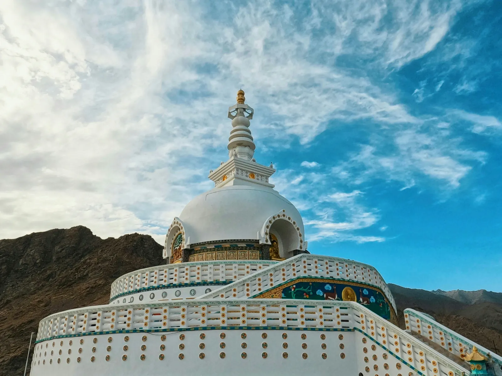
White domed Shanti Stupa in Leh with painted panels against a blue sky and dry hills

Shanti Stupa is the white peace pagoda on a hill above Leh. It was built in 1991 by the Japanese Buddhist monk Gyomyo Nakamura to mark 2,500 years of Buddhism, and the district Shanti Stupa page notes that relics of the Buddha enshrined by the 14th Dalai Lama lie at its base. Come at sunset for the view over Leh. A road also reaches the stupa, so you do not need to climb the long staircase in your first days.

Tso Moriri, Hanle and the Changthang plateau

Tso Moriri is a quieter, higher alternative to Pangong. It lies about 240 km from Leh via Upshi, Chumathang and Sumdo, which the district says takes about 6 to 7 hours, and it is part of the Tsomoriri Wetland Conservation Reserve, a Ramsar site since 19 August 2002. Hanle, about 260 km from Leh at around 4,500 m, is home to the Indian Astronomical Observatory and the Hanle Dark Sky Reserve. The Indian Institute of Astrophysics says the reserve was declared in December 2022 and covers a radius of about 22 km around Hanle. Both places are very high, very cold at night and have basic lodges and homestays. They suit travellers who have already done Nubra and Pangong without trouble.

Which Ladakh festivals happen when?

Ladakh's monastery festivals follow the Buddhist lunar calendar, so their Gregorian dates move each year. The Leh district festival calendar lists the months below. Dates for 2027 had not been published when we checked on 18 November 2026.

FestivalUsual monthWhere
DosmocheyFebruaryLeh, Likir, Diskit
Ladakh Winter Snow Leopard FestivalFebruaryHemis National Park, Rumbak
Apricot Blossom FestivalAprilCentral and lower Indus valley
Hemis TsechuJune (late June or the first half of July)Hemis Monastery
Yuru KabgyatJuneLamayuru
Phyang TsedupJulyPhyang Monastery
Korzok GustorJulyKorzok, Tso Moriri
Diskit GustorOctoberDiskit Monastery
Thiksey GustorNovemberThiksey Monastery

For Hemis Tsechu 2027, watch the Leh district and Hemis Monastery announcements in spring 2027. The festival falls on the 10th day of a lunar month, so its Gregorian date shifts from year to year.

Checked: 18 Nov 2026, Leh district tourist place pages and festival calendar, Ramsar Sites Information Service, Indian Institute of Astrophysics.

How do you get to Leh: by flight or by road?

From Kathmandu, the simplest way to Leh is to fly Kathmandu to Delhi (about 1.5 to 2 hours non-stop), then take a domestic flight from Delhi to Leh (about an hour). Delhi to Leh flights run all year, weather permitting. By road, the Manali to Leh highway is the classic overland route in summer and crosses some of the highest passes in the Himalaya. It is spectacular, but it takes two days and needs good health.

Leh's airport is Kushok Bakula Rimpochee Airport (IATA code IXL), at about 3,256 m. It is often described as India's highest commercial airport. Non-stop flights connect it with Delhi all year, and airline schedules also list a few other Indian cities, some only in season. Flights operate mainly in the morning, because strong afternoon winds in the mountains make later landings difficult. Weather delays and cancellations happen, especially in winter. If you are connecting from Kathmandu, avoid a same-day international to Leh connection on separate tickets. A night in Delhi gives you a buffer, and our guide to places to visit in Delhi can fill a spare evening.

The main ways to reach Leh, compared:

RouteDistance or timeSeasonGood forConsider
Fly Kathmandu to Delhi, then Delhi to LehAbout 1.5 to 2 hours, then about 1 hourAll yearMost travellers, short trips, families, older travellersFastest climb in altitude, so the 48-hour rest is essential
Fly to Leh from Mumbai, Chandigarh or JammuVaries by citySome routes seasonalDiaspora and Indian connectionsCheck current schedules with the airlines
Manali to Leh highwayAbout 427 to 473 km depending on the source (BRO and district figures), usually 2 days with a night stopRoughly May or June to September or OctoberBikers, road-trippers, fit travellersVery high passes, cold night halts, landslides and snow
Srinagar to Leh road via Zoji La and KargilAbout 434 km (district figure)The district gives May to November or December; winter closure length variesAn alternative road access routeCheck road status before travel

The Manali route has become easier since the Atal Tunnel opened on 3 October 2020. The 9.02 km tunnel runs under the Rohtang Pass at about 3,000 m and saves around four hours between Manali and the Lahaul valley, as Deccan Herald reported at the opening. Beyond the tunnel, the highway still crosses Baralacha La, at over 16,000 ft, and other passes. Those sections reopen only after the BRO clears the winter snow, so the tunnel does not make the route open all year.

Kathmandu to Manali is a long overland journey in itself. To compare trains, domestic flights and hired cars for that leg, see our guide on how to get around India. Inside Ladakh, most visitors use local taxis or a rented car or motorbike with a driver who knows the high roads. Self-drive visitors should check the current rules on outside vehicles and local permits with the Leh administration before they go.

Checked: 18 Nov 2026, Leh district How to Reach page, airport published data, Newswav and The Tribune (Manali to Leh highway, May 2026).

What should you pack and know about phone connectivity?

Pack for cold mornings, strong sun and dry air, even in July. If you rely on an Indian SIM, ask your operator before you travel whether it works in Ladakh. Mobile coverage is good in Leh and patchy or absent in parts of Nubra, Pangong, Tso Moriri and on the high passes. Download offline maps and tell someone your route before you leave town.

Packing list for a summer Ladakh trip

  • Layers: thermal base layer, fleece and a warm down or synthetic jacket. Pangong and Khardung La can be near freezing on a July morning.
  • Sun protection: UV is intense at 3,500 m and above. Bring sunglasses, a brimmed hat, high-factor sunscreen and lip balm.
  • Dry air care: moisturiser, saline nasal spray and a refillable water bottle (aim for the 2 to 3 litres a day the health advisory recommends).
  • Health kit: any prescription altitude medicine your doctor advises, your regular medicines in their original packs, and basic first aid. Check that your travel insurance covers high altitude and emergency evacuation.
  • Documents: your passport or other valid ID, an Indian visa where needed, permit printouts and several photocopies for checkpoints.
  • Power: a power bank and spare camera batteries. Batteries drain faster in the cold, and remote camps may have limited charging.
  • Cash: carry some Indian rupees for remote villages and camps, where cards and network coverage can be unreliable.

Do prepaid SIM cards work in Ladakh?

Possibly not, and we could not confirm the current rule. Many visitors report that prepaid SIMs issued in other Indian states do not work in Ladakh while postpaid connections do, but we found no current official notice from India's Department of Telecommunications that sets this out. Ask your operator before you travel.

For visitors from Nepal and abroad:

  • Nepali SIM cards: check with Nepal Telecom or Ncell whether international roaming works in Ladakh specifically, not just "in India".
  • Coverage: expect good coverage in Leh town, coverage in the main villages of Nubra and around Pangong that depends on the network, and dead zones on passes and long stretches of road.

How should Nepali travellers plan a Ladakh trip?

Nepali travellers have two real advantages in Ladakh: no Indian visa, and a cultural and mountain landscape that already feels familiar. The main risks are timing and altitude. Plan around Nepal's own calendar, not just Ladakh's.

  • Dashain and Tihar fall late for Ladakh. These festivals usually fall between late September and early November, when Ladakh is at the very end of its season, with freezing nights, seasonal lake camps winding down and the Manali road near closure. A Dashain trip works best as a fly-in Leh, Nubra and monastery trip rather than a road journey.
  • Ladakh is a monsoon escape. From June to September, while Nepal's trekking trails are wet, cloudy and leech-prone lower down, Ladakh's rain shadow keeps it mostly dry. This is the best match for Nepali travellers who can take summer leave.
  • Trekking experience helps, but it is not acclimatisation. Fitness and mountain sense from Nepal treks are valuable, but the fly-in ascent to Leh still calls for the full 48-hour rest.
  • NRNs and the diaspora: if you hold a foreign passport, you are treated as a foreign national. You need an Indian visa and, for most nationalities, a Protected Area Permit. Families travelling with members on different passports should check each person's rule separately.
  • Elderly parents: Leh itself can work for older travellers in good health, with a doctor's clearance, a slow pace and sleeping at Leh or Nubra rather than at the lakes.

Ladakh fits naturally into a wider India journey: Delhi on the way in, perhaps Rishikesh or the hill stations before or after. Our round-up of things to do in India has ideas for the rest of the trip. To see how Ladakh can sit alongside other Indian regions in a single holiday, browse the India tour packages page.

How we checked this guide: every permit rule, fee notice, health advisory, altitude and road date above was checked against the named official or primary source on 18 November 2026. Where official pages contradicted each other or another reliable source, we showed both figures. Ladakh's permit and road rules change often, so confirm the latest position with the Leh district administration before you travel.

Frequently asked questions

What is the best month for Ladakh?

July and August are the most reliable months for Ladakh, with both road routes normally open, warm days and dry weather while the monsoon covers the rest of India and Nepal. June and September are almost as good and a little quieter. For winter landscapes or the Chadar trek, January and February are the months, but only by air and with serious cold-weather gear.

Do Nepali citizens need a permit for Pangong Lake?

We could not find an official statement that settles it. Ladakh's official portal names the nationalities that need Ministry of Home Affairs clearance, and Nepal is not on that list. The permit rules it hosts exempt only citizens of Bhutan, so do not assume a Nepali passport is exempt. Confirm with the Deputy Commissioner's office in Leh or the permit portal before you travel.

How many days should you rest in Leh first?

Rest at least 48 hours in Leh before going higher. The Leh district health advisory asks every visitor to acclimatise for at least two days, with complete rest for the first 24 to 36 hours and no strenuous activity. A third easy day in Leh, or a night in lower Nubra before Pangong, makes the rest of a Ladakh trip much safer and more enjoyable.

Is Khardung La really the highest motorable road?

No. Khardung La's summit signs say 5,602 m (18,379 ft), but GPS and satellite data put it at about 5,359 m. The Leh district itself now calls it the second-highest motorable pass after Umling La, where the BRO's road reaches about 19,024 ft. In 2025 the BRO reported an even higher road at Mig La, about 19,400 ft, also in Ladakh.

Do prepaid SIM cards work in Ladakh?

Possibly not, if the prepaid SIM comes from another Indian state. Many visitors report that such SIMs stop working in Ladakh while postpaid ones keep working, but we could not find a current official notice that confirms this. Check with your mobile operator before you go. Nepali travellers should ask Nepal Telecom or Ncell about roaming in Ladakh specifically.

Is Pangong Lake frozen in January?

Yes, Pangong Lake is normally frozen in January. The Leh district says the lake freezes completely in winter despite its brackish water, and January and February are usually the coldest months. Ice thickness varies, so stay off the ice unless local authorities or guides say it is safe. Winter road access depends on snow on the Chang La pass.

Can I fly to Leh in winter?

Yes. Flights from Delhi to Leh operate through the winter, even when the road routes into Ladakh are closed. Weather delays and cancellations are more common between December and February, so keep a spare day at each end of the trip and avoid tight same-day connections from Kathmandu or international flights on separate tickets.

Is Ladakh safe for elderly travellers?

Ladakh can be safe for elderly travellers in good health who see a doctor before the trip, especially anyone with heart or lung conditions. The CDC advises travellers with chronic illness to consult a physician experienced in altitude medicine. Plan two or three slow days in Leh, sleep at Leh or Nubra, and treat Khardung La and Pangong as optional.

Is it better to fly to Leh or drive from Manali?

Fly if you are short on time, travelling with children or older relatives, or visiting outside June to September. Drive from Manali if you are fit, have extra days and want the road journey itself, as bikers do. The flight is faster but raises altitude abruptly. The road is slower but crosses passes higher than Leh, so rest in Leh either way.

How does Ladakh's altitude compare with treks in Nepal?

Leh, at about 3,500 m, is similar to Namche Bazaar, and Khardung La, at about 5,359 m measured, is about the height of Everest Base Camp. The big difference is speed. In Nepal you walk up over days. In Ladakh you can fly to over 3,200 m in an hour and drive over a 5,300 m pass soon after, so acclimatise as if you had never trekked.

Ladakh jana Nepali lai Indian visa chahincha?

No. Nepali citizens do not need an Indian visa to visit Ladakh. Carry the identity document your airline accepts for travel to India, and keep it with you for checkpoints in Ladakh. The separate question of a Protected Area Permit for Pangong or Nubra should be confirmed with the Leh district administration before travel.
Tags
India
Share
G
Gomayu Team
Writer at Gomayu
Keep reading